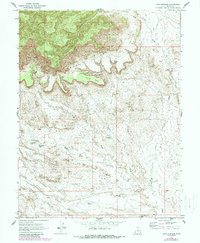
1970 Map of Cisco Springs
USGS Topo · Published 1987About this map
The dramatic southern escarpment of the Book Cliffs dominates this landscape, dropping away into a complex network of canyons and washes toward the Grand County desert floor. This 1970 survey, later updated with photorevised data in the 1980s, reveals a remote ranching and resource territory marked by critical water sources like Cisco Springs and several scattered livestock catchments such as Struchmine Pond and Dead Sheep Pond. The terrain transitions from the high elevations of Tepee Point and Corral Point down into the ironically named Death Valley and across the open expanse of Danish Flat. Movement through this high-desert environment is dictated by the topography, with a system of Jeep Trails navigating between the Bread Knolls and the steep walls of Corral Canyon. The map provides a detailed record of land use before modern changes, documenting the location of various Corrals and early Drill Holes that signal the region's agricultural and mineral history.
Find a feature on this map
24 named features on this map. Tap any name to fly to it.
Don’t see what you’re looking for? This feature index may not catch every label — zoom into the map to look around manually.
Map Details
Editions of this 1970 Cisco Springs Map
3 editions found
Other maps of this area

1885 · East Tavaputs
USGS Topo · 1:250,000

1885 · La Sal
USGS Topo · 1:250,000

1956 · Moab
USGS Topo · 1:250,000

1956 · Grand Junction
USGS Topo · 1:250,000

1958 · Thompson
USGS Topo · 1:62,500

1958 · Cisco
USGS Topo · 1:62,500

1959 · Grand Junction
USGS Topo · 1:250,000

1959 · Moab
USGS Topo · 1:250,000

1960 · Moab
USGS Topo · 1:250,000

1960 · Grand Junction
USGS Topo · 1:250,000