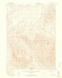
1958 Map of Citadel Plateau
USGS Topo · Published 1960About this map
Citadel Plateau and the surrounding high desert of Northwest Colorado are defined by a complex network of draws and gulches in this late 1950s survey. The Yampa River carves through the northeastern corner near Juniper Canyon and Juniper Mtn, marking a distinct hydrological break from the more arid terrain to the south. Land use at the time centered on isolated ranching outposts such as Shelton Ranch and Sweeney Ranch, which were situated near seasonal water sources like Wolf Creek and Deception Creek. Evidence of mid-century industrial expansion is visible through the Pipeline crossing the northern tier and the Maudlin Gulch Oil Field in the southeast. These features, along with names like Wild Horse Ridge, reflect a landscape transitioning between traditional cattle ranching and the emerging energy economy of the era.
Find a feature on this map
52 named features on this map. Tap any name to fly to it.
Don’t see what you’re looking for? This feature index may not catch every label — zoom into the map to look around manually.
Map Details
Editions of this 1958 Citadel Plateau Map
5 editions found

Other maps of this area

1907 · White River
USGS Topo · 1:125,000

1910 · Danforth Hills
USGS Topo · 1:125,000

1910 · White River
USGS Topo · 1:125,000

1912 · Meeker
USGS Topo · 1:62,500

1912 · Axial
USGS Topo · 1:62,500

1914 · Meeker
USGS Topo · 1:62,500

1914 · Axial
USGS Topo · 1:62,500

1916 · Craig
USGS Topo · 1:125,000

1954 · Vernal
USGS Topo · 1:250,000

1954 · Craig
USGS Topo · 1:250,000