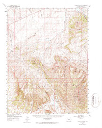
1958 Map of Citadel Plateau
USGS Topo · Published 1987About this map
The Danforth Hills and the expansive Citadel Plateau dominate this 1950s terrain in Moffat County, defined by a complex network of canyons and gulches. Regional industry is clearly established by the Mauldin Gulch Oil Field and scattered Oil Wells, marking the post-war energy development of the Colorado Plateau. In the northern reaches, the Yampa River carves through Juniper Canyon alongside the Maybell Ditch, illustrating early irrigation infrastructure in this high-elevation environment.
Find a feature on this map
50 named features on this map. Tap any name to fly to it.
Don’t see what you’re looking for? This feature index may not catch every label — zoom into the map to look around manually.
Map Details
Editions of this 1958 Citadel Plateau Map
5 editions found

Other maps of this area

1907 · White River
USGS Topo · 1:125,000

1910 · Danforth Hills
USGS Topo · 1:125,000

1910 · White River
USGS Topo · 1:125,000

1912 · Meeker
USGS Topo · 1:62,500

1912 · Axial
USGS Topo · 1:62,500

1914 · Meeker
USGS Topo · 1:62,500

1914 · Axial
USGS Topo · 1:62,500

1916 · Craig
USGS Topo · 1:125,000

1954 · Vernal
USGS Topo · 1:250,000

1954 · Craig
USGS Topo · 1:250,000