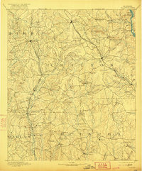
1891 Map of Clanton
USGS Topo · Published 1921About this map
The Clanton area during the late nineteenth century was a critical rail and river hub where the Louisville and Nashville Railroad and the Mobile and Ohio Railroad defined the local economy. This landscape is marked by several early family-run commercial outposts, including Hunts Store, Ousley Store, and Booms Store, alongside industrial sites like Hunts Mill and Willis Mill. The topographic survey reveals a rugged interior bisected by the Middle Fork of Mulberry Creek, where transit relied on older river crossings like Pages Old Ferry, Adams Ferry, and the Clanton Ford. Settlements such as Plantersville and Stanton appear as established rail stops, while the presence of Old Kingston and Independence signifies the early nineteenth-century settlement patterns of central Alabama before the expansion of the modern county seats.
Find a feature on this map
83 named features on this map. Tap any name to fly to it.
Don’t see what you’re looking for? This feature index may not catch every label — zoom into the map to look around manually.
Map Details
Editions of this 1891 Clanton Map
5 editions found
Other maps of this area

1890 · Bessemer
USGS Topo · 1:125,000

1890 · Talladega
USGS Topo · 1:125,000

1891 · Clanton
USGS Topo · 1:125,000

1892 · Talladega
USGS Topo · 1:125,000

1892 · Bessemer
USGS Topo · 1:125,000

1899 · Brookwood
USGS Topo · 1:125,000

1901 · Wetumpka
USGS Topo · 1:125,000

1903 · Wetumpka
USGS Topo · 1:125,000

1909 · Columbiana
USGS Topo · 1:62,500

1910 · Montevallo
USGS Topo · 1:62,500