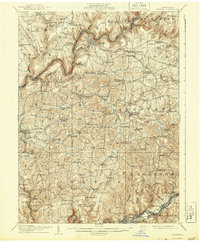
1907 Map of Clarion
USGS Topo · Published 1943About this map
The Clarion River winds deeply through the heart of the county, carving a path between the settlements of Clarion and Shippenville. This early 20th-century landscape reveals a region defined by its diverse transportation and industrial infrastructure, where the Pittsburgh Summerville And Clarion RR and the Baltimore And Ohio RR connected rural townships to broader markets. The distribution of civic life is evident in the numerous small educational buildings like Buckhorn School and Independence School, alongside local religious centers such as Concord Church and Leatherwood Church.
Find a feature on this map
122 named features on this map. Tap any name to fly to it.
Don’t see what you’re looking for? This feature index may not catch every label — zoom into the map to look around manually.
Map Details
Editions of this 1907 Clarion Map
5 editions found
Other maps of this area

1900 · Kittanning
USGS Topo · 1:62,500

1901 · Rural Valley
USGS Topo · 1:62,500

1902 · Kittanning
USGS Topo · 1:62,500

1903 · Rural Valley
USGS Topo · 1:62,500

1906 · Clarion
USGS Topo · 1:62,500

1907 · Clarion
USGS Topo · 1:62,500

1907 · Foxburg
USGS Topo · 1:62,500

1908 · Foxburg
USGS Topo · 1:62,500

1909 · Smicksburg
USGS Topo · 1:62,500

1918 · Loleta
USGS Topo · 1:62,500