
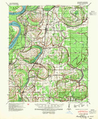
1939 Map of Clayton
USGS Topo · Published 1941About this map
Tunica and its neighboring delta settlements sit within a landscape of oxbows and bayous just east of the Mississippi River. The terrain is defined by the shifting course of the river, leaving behind landforms like Mhoon Bend, Fox Island Bend, and the expansive Old River Lake. This era in Tunica County shows a dense network of rural community centers, often centered around combined institutions such as Shady Grove Ch Sch & Cem or Strangers Hope Ch & Sch.
Find a feature on this map
105 named features on this map. Tap any name to fly to it.
Don’t see what you’re looking for? This feature index may not catch every label — zoom into the map to look around manually.
Map Details
Editions of this 1939 Clayton Map
2 editions found
Other maps of this area

1908 · Lula
USGS Topo · 1:24,000

1908 · Dundee
USGS Topo · 1:24,000

1908 · Hollywood
USGS Topo · 1:24,000

1908 · Moon Lake
USGS Topo · 1:24,000

1908 · Walnut Lake
USGS Topo · 1:24,000

1910 · Dundee
USGS Topo · 1:31,680

1910 · Walnut Lake
USGS Topo · 1:31,680

1912 · Moon Lake
USGS Topo · 1:31,680

1912 · Lula
USGS Topo · 1:31,680

1913 · Hollywood
USGS Topo · 1:31,680