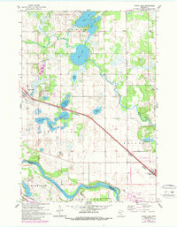
1961 Map of Clear Lake
USGS Topo · Published 1987About this map
The Mississippi River forms a major geographic boundary along the southern edge of this Sherburne County landscape, while the Northern Great Pacific Northern railroad dictates the primary corridor of development between the settlements of Clear Lake and Becker. The terrain is defined by an intricate network of water bodies, including the large expanse of Elk Lake and the smaller, clustered basins of Jones Lake, Mosford Lake, and Crescent Lake. These features reflect the region's post-glacial topography, which supported a diverse mix of wetlands and prairie environments.
Find a feature on this map
30 named features on this map. Tap any name to fly to it.
Don’t see what you’re looking for? This feature index may not catch every label — zoom into the map to look around manually.
Map Details
Editions of this 1961 Clear Lake Map
3 editions found
Other maps of this area

1950 · St. Cloud
USGS Topo · 1:62,500

1951 · Annandale
USGS Topo · 1:62,500

1953 · Saint Cloud
USGS Topo · 1:250,000

1953 · Stillwater
USGS Topo · 1:250,000

1955 · Stillwater
USGS Topo · 1:250,000

1957 · Saint Cloud
USGS Topo · 1:250,000

1958 · Stillwater
USGS Topo · 1:250,000

1958 · Saint Cloud
USGS Topo · 1:250,000

1961 · Clear Lake
USGS Topo · 1:24,000

1961 · Silver Creek
USGS Topo · 1:24,000