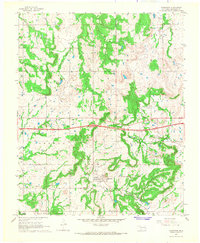
1967 Map of Clearview
USGS Topo · Published 1968About this map
Clearview stands as a focal point in this 1960s survey of Okfuskee County, situated above the winding path of Alabama Creek. The landscape is a complex intersection of rural settlement and industrial extraction, dominated by numerous petroleum operations including the Morse Oil and Gas Field and the Okemah Oil Field. This era of the Oklahoma interior is marked by the presence of local landmarks such as Creek Chapel and Salt Creek Ch, which served the community alongside the Clearview Cem.
Find a feature on this map
21 named features on this map. Tap any name to fly to it.
Don’t see what you’re looking for? This feature index may not catch every label — zoom into the map to look around manually.
Map Details
Editions of this 1967 Clearview Map
2 editions found
Other maps of this area

1900 · Wewoka
USGS Topo · 1:125,000

1901 · Nuyaka
USGS Topo · 1:125,000

1954 · Oklahoma City
USGS Topo · 1:250,000

1957 · Oklahoma City
USGS Topo · 1:250,000

1963 · Oklahoma City
USGS Topo · 1:250,000
1967 · Pharoah
USGS Topo · 1:24,000

1967 · Okemah SE
USGS Topo · 1:24,000

1967 · Weleetka
USGS Topo · 1:24,000

1967 · Okemah
USGS Topo · 1:24,000
1967 · Dustin
USGS Topo · 1:24,000