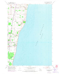
1954 Map of Cleveland East
USGS Topo · Published 1974About this map
Lake Michigan's western shoreline defines this landscape, where small coastal communities like Cleveland and Nordheim sit atop the bluffs of Centerville and Mosel townships. This mid-century view shows a rural economy organized around the Chicago and North Western railroad and a series of creeks, including Centerville Creek, Fischer Creek, and Point Creek, that cut through the glacial till toward the lake. The map reveals a dense network of local institutions essential for genealogical research, such as White Trail Sch, Point River Sch, and the St John Cem near Newton. The transition from agrarian land use to coastal development is evident in the cluster of structures at Cleveland, while the surrounding townships maintain their grid of farmsteads and rural schoolhouses during this era of Wisconsin's lakeshore history.
Find a feature on this map
20 named features on this map. Tap any name to fly to it.
Don’t see what you’re looking for? This feature index may not catch every label — zoom into the map to look around manually.
Map Details
Editions of this 1954 Cleveland East Map
3 editions found
Other maps of this area

1954 · Manitowoc
USGS Topo · 1:62,500

1954 · Cleveland
USGS Topo · 1:24,000

1954 · St. Wendel
USGS Topo · 1:24,000

1954 · Sheboygan North
USGS Topo · 1:62,500

1954 · Sheboygan North
USGS Topo · 1:24,000

1954 · Howards Grove
USGS Topo · 1:62,500

1954 · Howards Grove
USGS Topo · 1:24,000

1954 · Reedsville
USGS Topo · 1:62,500

1954 · Manitowoc
USGS Topo · 1:24,000

1954 · Milwaukee
USGS Topo · 1:250,000