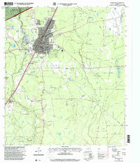
1997 Map of Cleveland
USGS Topo · Published 2000About this map
The growing town of Cleveland serves as a hub for both the logging and petroleum industries in this corner of East Texas. To the northwest, the Sam Houston National Forest edges into the map area near the San Jacinto and Liberty County line, while the Southern Pacific Railroad cuts through the center of town. Local infrastructure is well-defined, featuring the Leggett Memorial Hospital, North Side School, and the Cleveland Airport to the northeast. Beyond the urban grid, the landscape is shaped by the East Fork San Jacinto River and Tarkington Bayou. Pockets of industry are evident at the South Cleveland Oil Field and Pelican Oil Field, while smaller historical sites like Pin Oak Cemetery and New Salem Church dot the countryside, reflecting the area's rural roots.
Find a feature on this map
43 named features on this map. Tap any name to fly to it.
Don’t see what you’re looking for? This feature index may not catch every label — zoom into the map to look around manually.
Map Details
Editions of this 1997 Cleveland Map
This is the sole edition of this map. No revisions or reprints were ever made.
Other maps of this area

1943 · Liberty
USGS Topo · 1:125,000

1954 · Beaumont
USGS Topo · 1:250,000

1955 · Rayburn
USGS Topo · 1:62,500

1955 · Liberty
USGS Topo · 1:62,500

1957 · Beaumont
USGS Topo · 1:250,000

1958 · Fostoria
USGS Topo · 1:24,000

1958 · Cleveland
USGS Topo · 1:24,000

1958 · Westcott
USGS Topo · 1:24,000

1958 · Bear Creek
USGS Topo · 1:24,000

1959 · Plum Grove
USGS Topo · 1:24,000