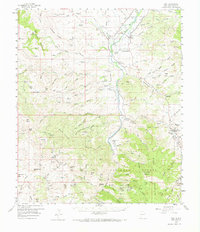
1959 Map of Cliff
USGS Topo · Published 1966About this map
The Gila River valley near the Arizona border reveals a landscape defined by ranching and resource extraction during the late 1950s. The settlements of Cliff, Gila, and Riverside cluster along the river and its tributary Duck Creek, where the floodplain provided a corridor for development. Outside of these small hubs, the terrain is dominated by the sprawling Gila National Forest and the Burro Mountains.
Find a feature on this map
103 named features on this map. Tap any name to fly to it.
Don’t see what you’re looking for? This feature index may not catch every label — zoom into the map to look around manually.
Map Details
Editions of this 1959 Cliff Map
2 editions found

Other maps of this area

1909 · Silver City
USGS Topo · 1:125,000

1910 · Mogollon
USGS Topo · 1:125,000

1911 · Alum Mountain
USGS Topo · 1:125,000

1912 · Mogollon
USGS Topo · 1:125,000

1913 · Alum Mountain
USGS Topo · 1:125,000

1949 · Circle Mesa
USGS Topo · 1:24,000

1950 · Dorsey Ranch
USGS Topo · 1:24,000

1950 · Wind Mountain
USGS Topo · 1:24,000

1951 · Circle Mesa
USGS Topo · 1:24,000

1951 · Dorsey Ranch
USGS Topo · 1:24,000