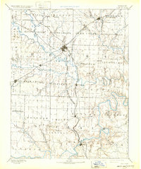
1894 Map of Clinton
USGS Topo · Published 1932About this map
Clinton serves as the primary hub for this late-19th-century landscape, where three major rail lines converge amidst the winding tributaries of the Osage River. The Missouri Pacific Railroad, the Kansas City Clinton and Springfield Railroad, and the Kansas City and Southern Railroad carve distinct paths across the terrain, linking smaller settlements like Brownington, Lowry, and La Due. To the south, Osceola sits at a strategic bend where Gallinipper Creek and Salt Creek join the larger river system.
Find a feature on this map
79 named features on this map. Tap any name to fly to it.
Don’t see what you’re looking for? This feature index may not catch every label — zoom into the map to look around manually.
Map Details
Editions of this 1894 Clinton Map
4 editions found

Other maps of this area

1884 · Bolivar
USGS Topo · 1:125,000

1885 · Warrensburg
USGS Topo · 1:125,000

1886 · Nevada
USGS Topo · 1:125,000

1886 · Stockton
USGS Topo · 1:125,000

1887 · Clinton
USGS Topo · 1:125,000

1887 · Harrisonville
USGS Topo · 1:125,000

1887 · Sedalia
USGS Topo · 1:125,000

1887 · Warsaw
USGS Topo · 1:125,000

1887 · Butler
USGS Topo · 1:125,000

1887 · Warrensburg
USGS Topo · 1:125,000