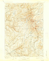
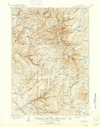
1901 Map of Cloud Peak
USGS Topo · Published 1925About this map
Cloud Peak dominates the skyline of the Big Horn Mountains in this late nineteenth-century survey, conducted just as the Big Horn National Forest was established. The map meticulously documents the high alpine environment, from the glaciers near Black Tooth to the deep incisions of Tensleep Canyon and Leigh Canyon in the southwest. Rare early Wyoming settlements like Rome and Burke appear at lower elevations, while the interior is a network of named water bodies including Lake Solitude and the Paintrock Lakes.
Find a feature on this map
63 named features on this map. Tap any name to fly to it.
Don’t see what you’re looking for? This feature index may not catch every label — zoom into the map to look around manually.
Map Details
Editions of this 1901 Cloud Peak Map
7 editions found

Other maps of this area

1895 · Dayton
USGS Topo · 1:125,000

1898 · Bald Mountain
USGS Topo · 1:125,000

1899 · Cloud peak
USGS Topo · 1:125,000

1900 · Fort McKinney
USGS Topo · 1:125,000

1901 · Cloud Peak
USGS Topo · 1:125,000

1901 · Dayton
USGS Topo · 1:125,000

1901 · Bald Mountain
USGS Topo · 1:125,000

1903 · Fort McKinney
USGS Topo · 1:125,000

1909 · Sheridan
USGS Topo · 1:125,000

1911 · Sheridan
USGS Topo · 1:125,000