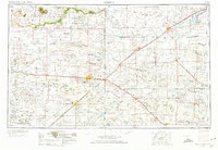
1954 Map of Clovis
USGS Topo · Published 1974About this map
Clovis and its neighboring High Plains settlements anchor this mid-century survey of the Llano Estacado, where the vast drainage networks of Blackwater Draw and Running Water Draw cross the New Mexico and Texas border. The map highlights a critical junction of the Atchison Topeka and Santa Fe railroad, with industrial and military hubs like Cannon AFB and Cameo station defining the local economy. Beyond the larger hubs of Hereford and Portales, the landscape is dotted with smaller rural communities such as Lazbuddie and St Vrain, many of which were established as rail stops or centers for dryland farming. The dramatic geological break of The Caprock is visible in the northwest, while the southern reach of the map is defined by the Sand Hills and the saline waters of Salt Lake. This record captures the region during a period of agricultural and military expansion, before significant changes in modern water management and land use altered the local geography.
Find a feature on this map
98 named features on this map. Tap any name to fly to it.
Don’t see what you’re looking for? This feature index may not catch every label — zoom into the map to look around manually.
Map Details
Editions of this 1954 Clovis Map
4 editions found
Other maps of this area

1930 · Tucumcari
USGS Topo · 1:125,000

1954 · Lubbock
USGS Topo · 1:250,000

1954 · Santa Fe
USGS Topo · 1:250,000

1954 · Fort Sumner
USGS Topo · 1:250,000

1954 · Tucumcari
USGS Topo · 1:250,000

1954 · Amarillo
USGS Topo · 1:250,000

1954 · Plainview
USGS Topo · 1:250,000

1954 · Clovis
USGS Topo · 1:250,000

1954 · Brownfield
USGS Topo · 1:250,000

1955 · Roswell
USGS Topo · 1:250,000