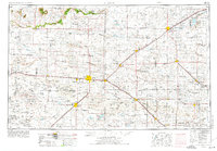
1954 Map of Clovis
USGS Topo · Published 1975About this map
Cannon AFB stands as a central fixture of the High Plains landscape in this 1970s revision of a mid-century survey. The terrain is defined by the dramatic escarpment of The Caprock, where the elevated Llano Estacado gives way to numerous intermittent watercourses such as Frio Draw, Running Water Draw, and Blackwater Draw. These seasonal drainage patterns, alongside isolated water bodies like Mustang Lake and Garcia Lake, dictated the layout of early ranching and agriculture across the New Mexico-Texas border.
Find a feature on this map
112 named features on this map. Tap any name to fly to it.
Don’t see what you’re looking for? This feature index may not catch every label — zoom into the map to look around manually.
Map Details
Editions of this 1954 Clovis Map
4 editions found
Other maps of this area

1930 · Tucumcari
USGS Topo · 1:125,000

1954 · Lubbock
USGS Topo · 1:250,000

1954 · Santa Fe
USGS Topo · 1:250,000

1954 · Fort Sumner
USGS Topo · 1:250,000

1954 · Tucumcari
USGS Topo · 1:250,000

1954 · Amarillo
USGS Topo · 1:250,000

1954 · Plainview
USGS Topo · 1:250,000

1954 · Clovis
USGS Topo · 1:250,000

1954 · Brownfield
USGS Topo · 1:250,000

1955 · Roswell
USGS Topo · 1:250,000