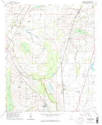
1964 Map of Coahoma
USGS Topo · Published 1965About this map
The Illinois Central railroad corridor serves as the primary axis for this Delta landscape, connecting the town of Coahoma with rural outposts like Rudyard and Clover Hill. The map reveals a highly structured agricultural economy, documented through several named estates such as Oakhurst Plantation, Irvin Plantation, and the King & Anderson Ranch. These large holdings are interspersed with numerous small country churches, including Mt Zion Ch, Shady Grove Ch, and St John Ch, which served the local farming communities.
Find a feature on this map
49 named features on this map. Tap any name to fly to it.
Don’t see what you’re looking for? This feature index may not catch every label — zoom into the map to look around manually.
Map Details
Editions of this 1964 Coahoma Map
2 editions found
Other maps of this area

1908 · Lula
USGS Topo · 1:24,000

1908 · Coahoma
USGS Topo · 1:24,000

1908 · Moon Lake
USGS Topo · 1:24,000

1908 · Jonestown
USGS Topo · 1:24,000

1910 · Coahoma
USGS Topo · 1:31,680

1910 · Jonestown
USGS Topo · 1:31,680

1912 · Moon Lake
USGS Topo · 1:31,680

1912 · Lula
USGS Topo · 1:31,680

1932 · Tutwiler
USGS Topo · 1:48,000

1932 · Marks
USGS Topo · 1:48,000