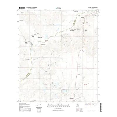
2015 Map of Cocodrie Lake
USGS Topo · Published 2015About this map
Bayou Cocodrie winds through the borderlands of Rapides and Evangeline Parishes, creating a labyrinth of landings and swampy islands. This survey captures a region defined by its waterfront settlements, including Squealer Point Landing, Johnson Landing, and Bennett Bay Landing. To the south, the village of Turkey Creek serves as a local hub near the shores of Cocodrie Lake, while the landscape is dotted with generational landmarks like Belle Chaney Spring.
Find a feature on this map
67 named features on this map. Tap any name to fly to it.
Don’t see what you’re looking for? This feature index may not catch every label — zoom into the map to look around manually.
Map Details
Editions of this 2015 Cocodrie Lake Map
This is the sole edition of this map. No revisions or reprints were ever made.
Other maps of this area

1935 · Beaver
USGS Topo · 1:31,680

1935 · Turkey Creek
USGS Topo · 1:62,500

1935 · Lecompte
USGS Topo · 1:62,500

1942 · Oakdale
USGS Topo · 1:62,500

1949 · Glenmora
USGS Topo · 1:31,680

1949 · Turkey Creek
USGS Topo · 1:62,500

1952 · Lake Charles
USGS Topo · 1:250,000

1953 · Alexandria
USGS Topo · 1:250,000
1954 · Beaver
USGS Topo · 1:31,680

1954 · Lake Charles
USGS Topo · 1:250,000