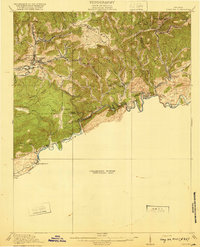
1920 Map of Coeburn
USGS Topo · Published 1920About this map
Coeburn and the surrounding coal country of Wise, Dickenson, and Russell counties are depicted during a period of intense industrial development following the 1916 survey. The map highlights a complex network of transportation, where the Norfolk and Western RR meets the Carolina Clinchfield and Ohio RR to serve high-altitude settlements like Bondtown and Banner. The rugged topography is defined by the winding Clinch River and numerous gaps such as Fuller Gap and Austin Gap, which dictated the path of both rail lines and early roads.
Find a feature on this map
51 named features on this map. Tap any name to fly to it.
Don’t see what you’re looking for? This feature index may not catch every label — zoom into the map to look around manually.
Map Details
Editions of this 1920 Coeburn Map
5 editions found

Other maps of this area

1886 · Grundy
USGS Topo · 1:125,000

1890 · Whitesburg
USGS Topo · 1:125,000

1890 · Grundy
USGS Topo · 1:125,000

1892 · Grundy
USGS Topo · 1:125,000

1892 · Whitesburg
USGS Topo · 1:125,000

1894 · Estillville
USGS Topo · 1:125,000

1897 · Bristol
USGS Topo · 1:125,000

1902 · Bristol
USGS Topo · 1:125,000

1912 · Pound
USGS Topo · 1:48,000

1913 · Clintwood
USGS Topo · 1:62,500