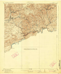
1920 Map of Coeburn
USGS Topo · Published 1924About this map
The Clinch River meanders through the rugged coalfields of southwest Virginia during a period of intense industrial expansion. This survey shows the critical intersection of the Norfolk and Western and the Carolina Clinchfield and Ohio railroads, which facilitated the movement of resources from mountain communities like Coeburn and Dante. The landscape is defined by prominent ridges such as Sand Ridge and Bull Ridge, with numerous gaps including Fuller Gap and Austin Gap providing natural passages for travel.
Find a feature on this map
57 named features on this map. Tap any name to fly to it.
Don’t see what you’re looking for? This feature index may not catch every label — zoom into the map to look around manually.
Map Details
Editions of this 1920 Coeburn Map
5 editions found

Other maps of this area

1886 · Grundy
USGS Topo · 1:125,000

1890 · Whitesburg
USGS Topo · 1:125,000

1890 · Grundy
USGS Topo · 1:125,000

1892 · Grundy
USGS Topo · 1:125,000

1892 · Whitesburg
USGS Topo · 1:125,000

1894 · Estillville
USGS Topo · 1:125,000

1897 · Bristol
USGS Topo · 1:125,000

1902 · Bristol
USGS Topo · 1:125,000

1912 · Pound
USGS Topo · 1:48,000

1913 · Clintwood
USGS Topo · 1:62,500