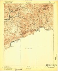
1920 Map of Coeburn
USGS Topo · Published 1920About this map
The Clinch River carves a deep path through these Virginia coalfields, where the industrial expansion of the early 20th century is evident in the dense rail networks of the Norfolk and Western Railway and the Clinchfield Railroad. In this preliminary 1920 edition, the landscape is defined by its ridge-and-valley structure, with Sand Ridge and Lick Creek Ridge separating small mountain communities. The map highlights a localized social infrastructure of rural education and communication, marking numerous neighborhood institutions like the Greenwood School and Fairview School. The presence of established post offices such as Dwins P O and Lowland P O alongside larger mining and rail hubs like Coeburn and Dante provides a detailed look at the settlement patterns of Wise, Dickenson, and Russell Counties during a peak era of Appalachian resource extraction and rail development.
Find a feature on this map
59 named features on this map. Tap any name to fly to it.
Don’t see what you’re looking for? This feature index may not catch every label — zoom into the map to look around manually.
Map Details
Editions of this 1920 Coeburn Map
5 editions found

Other maps of this area

1886 · Grundy
USGS Topo · 1:125,000

1890 · Whitesburg
USGS Topo · 1:125,000

1890 · Grundy
USGS Topo · 1:125,000

1892 · Grundy
USGS Topo · 1:125,000

1892 · Whitesburg
USGS Topo · 1:125,000

1894 · Estillville
USGS Topo · 1:125,000

1897 · Bristol
USGS Topo · 1:125,000

1902 · Bristol
USGS Topo · 1:125,000

1912 · Pound
USGS Topo · 1:48,000

1913 · Clintwood
USGS Topo · 1:62,500