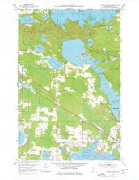
1953 Map of Cohasset West
USGS Topo · Published 1978About this map
Deer Lake and its intricate shoreline dominate this northern Minnesota landscape, where numerous bays and islands like Crawford Island define the local topography. This 1950s-era survey, with updates from the late 1960s, documents the area just west of the Cohasset settlement. The Mississippi River winds through the southern portion of the sheet, feeding into Blackwater Lake and Jay Gould Lake, while the Burlington Northern railroad cuts a diagonal path across the wetlands and forests, parallel to a major pipeline.
Find a feature on this map
44 named features on this map. Tap any name to fly to it.
Don’t see what you’re looking for? This feature index may not catch every label — zoom into the map to look around manually.
Map Details
Editions of this 1953 Cohasset West Map
3 editions found
Other maps of this area

1953 · Cohasset East
USGS Topo · 1:24,000

1953 · Siseebakwet Lake
USGS Topo · 1:24,000

1953 · Cohasset West
USGS Topo · 1:24,000

1953 · Grand Rapids
USGS Topo · 1:24,000

1954 · Hibbing
USGS Topo · 1:250,000

1957 · Hibbing
USGS Topo · 1:250,000

1958 · Hibbing
USGS Topo · 1:250,000

1964 · Hibbing
USGS Topo · 1:250,000

1970 · Deer River NE
USGS Topo · 1:24,000

1970 · Wabana Lake
USGS Topo · 1:24,000