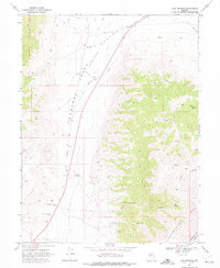
1969 Map of Cold Springs
USGS Topo · Published 1975About this map
Old Overland Road cuts across the northern reaches of Edwards Creek Valley, following a path established by early western transit. In this high desert landscape along the border of Churchill and Lander counties, the map documents several important archaeological sites related to the era of horse-drawn communication and transport. Notable landmarks include the Old Telegraph Station (Ruins) and the Old Stage Station (Ruins), as well as a more recent Stage Station located near the small settlement of Cold Springs.
Find a feature on this map
16 named features on this map. Tap any name to fly to it.
Don’t see what you’re looking for? This feature index may not catch every label — zoom into the map to look around manually.
Map Details
Editions of this 1969 Cold Springs Map
3 editions found
Other maps of this area

1955 · Millett
USGS Topo · 1:250,000

1959 · Millett
USGS Topo · 1:250,000

1966 · Clan Alpine Ranch
USGS Topo · 1:62,500

1966 · Edwards Creek Valley
USGS Topo · 1:62,500

1969 · Camp Creek Canyon
USGS Topo · 1:24,000

1969 · Cold Springs
USGS Topo · 1:24,000

1969 · Desatoya Peak
USGS Topo · 1:24,000

1969 · Carroll Summit
USGS Topo · 1:24,000

1969 · Basque Summit
USGS Topo · 1:24,000

1969 · Eastgate
USGS Topo · 1:24,000