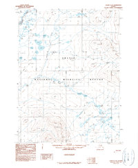
1990 Map of Coleen C-3
USGS Topo · Published 1990About this map
Arctic National Wildlife Refuge encompasses the vast majority of this landscape, characterized by the winding course of the Coleen River and its numerous associated oxbows and water bodies in the northwest. The terrain is defined by a dense network of mountain peaks and ridges, including prominent elevations such as 2031t and 2080t in the east. A Winter Trail cuts across the northern reaches, tracing a route through the drainage basins of Dorothy Creek and Lake Creek. This 1990 provisional survey captures the area as it was recorded in the late 1970s, showing a wilderness topography largely untouched by permanent settlement but crisscrossed by seasonal routes and hydraulic features. The presence of numerous numbered water levels, such as WL 1090t and WL 1135t, suggests a landscape shaped by significant seasonal fluctuations in the watershed.
Find a feature on this map
83 named features on this map. Tap any name to fly to it.
Don’t see what you’re looking for? This feature index may not catch every label — zoom into the map to look around manually.
Map Details
Editions of this 1990 Coleen C-3 Map
This is the sole edition of this map. No revisions or reprints were ever made.
Other maps of this area

1951 · Coleen
USGS Topo · 1:250,000

1956 · Coleen
USGS Topo · 1:250,000

1956 · Coleen B-2
USGS Topo · 1:63,360
1972 · Coleen D-4
USGS Topo · 1:63,360
1972 · Coleen D-2
USGS Topo · 1:63,360
1972 · Coleen D-3
USGS Topo · 1:63,360
1990 · Coleen C-2
USGS Topo · 1:63,360
1990 · Coleen B-3
USGS Topo · 1:63,360
1990 · Coleen C-4
USGS Topo · 1:63,360
1990 · Coleen B-4
USGS Topo · 1:63,360