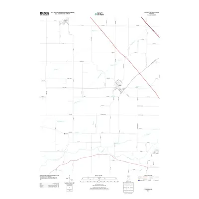
2013 Map of Colfax
USGS Topo · Published 2013About this map
Colfax serves as the central hub of this agricultural region in the early 21st century, situated where several local routes and a rail line intersect. The landscape is defined by a dense network of county roads that carve the terrain into a grid of large farm plots, typical of the Indiana plains. Flowing through this rural expanse are numerous small waterways, including Little Potato Cr, Withe Cr, and Bowers Cr, which drain the fields toward the larger Sugar Cr in the south. These creeks often dictate the subtle shifts in road patterns, contrasting with the rigid geometry of the surrounding section lines. Smaller settlement clusters like Clarks Hill and Bowers appear on the periphery, connected by long stretches of gravel and paved roads like W Manson Colfax Rd and S Broadview Rd. This survey documents a quiet rural economy where the layout of modern transport still follows the paths established by 19th-century pioneers.
Find a feature on this map
85 named features on this map. Tap any name to fly to it.
Don’t see what you’re looking for? This feature index may not catch every label — zoom into the map to look around manually.
Map Details
Editions of this 2013 Colfax Map
This is the sole edition of this map. No revisions or reprints were ever made.
Other maps of this area

1953 · Danville
USGS Topo · 1:250,000

1955 · Danville
USGS Topo · 1:250,000

1956 · Danville
USGS Topo · 1:250,000

1958 · Darlington
USGS Topo · 1:24,000

1958 · Kirkpatrick
USGS Topo · 1:24,000

1961 · Mulberry
USGS Topo · 1:24,000

1961 · Stockwell
USGS Topo · 1:24,000

1961 · Frankfort
USGS Topo · 1:24,000
1961 · Hazelrigg
USGS Topo · 1:24,000
1961 · Shannondale
USGS Topo · 1:24,000