
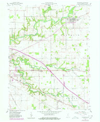
1958 Map of Darlington
USGS Topo · Published 1959About this map
Darlington sits at the northern confluence of Sugar Creek and Honey Creek, serving as a central hub for the small agricultural settlements and family-named landmarks of mid-century Montgomery County. The landscape is defined by the winding paths of several waterways, including Little Sugar Creek and the Walnut Fork, which cut through the level farmlands of Franklin, Union, and Walnut townships. Evidence of local community life is visible in the distribution of rural institutions like the Township Sch and Youngs Chapel, along with the Drive-in Theater west of Smartsburg.
Find a feature on this map
25 named features on this map. Tap any name to fly to it.
Don’t see what you’re looking for? This feature index may not catch every label — zoom into the map to look around manually.
Map Details
Editions of this 1958 Darlington Map
2 editions found
Other maps of this area

1953 · Danville
USGS Topo · 1:250,000

1953 · Indianapolis
USGS Topo · 1:250,000

1955 · Danville
USGS Topo · 1:250,000

1956 · Danville
USGS Topo · 1:250,000

1956 · Indianapolis
USGS Topo · 1:250,000

1956 · Crawfordsville
USGS Topo · 1:24,000

1956 · New Market
USGS Topo · 1:24,000

1957 · Indianapolis
USGS Topo · 1:250,000

1957 · New Ross
USGS Topo · 1:24,000

1958 · Linden
USGS Topo · 1:24,000