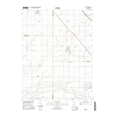
2016 Map of Colfax
USGS Topo · Published 2016About this map
The town of Colfax sits at the convergence of several county boundaries, serving as a hub for the agricultural lands of Clinton, Boone, Montgomery, and Tippecanoe counties. The grid of the town center includes streets like N Railroad St and S Meridian St, reflecting the rail-influenced layout typical of this part of Indiana. To the north, Clarks Hill occupies the corner of Tippecanoe County, while the small settlement of Bowers lies further south. The landscape is defined by its numerous family and community burial grounds, including Union Cem, Plainview Cem, and McKendree Cem, which offer significant touchstones for genealogical research. Natural drainage is provided by a network of creeks including Little Potato Cr, Withe Cr, and the larger Sugar Creek to the south. This modern survey illustrates how long-standing farm-to-market roads like W Manson Colfax Rd and Co Line Rd 1200 N continue to follow the original township lines established over a century ago.
Find a feature on this map
72 named features on this map. Tap any name to fly to it.
Don’t see what you’re looking for? This feature index may not catch every label — zoom into the map to look around manually.
Map Details
Editions of this 2016 Colfax Map
This is the sole edition of this map. No revisions or reprints were ever made.
Other maps of this area

1953 · Danville
USGS Topo · 1:250,000

1955 · Danville
USGS Topo · 1:250,000

1956 · Danville
USGS Topo · 1:250,000

1958 · Darlington
USGS Topo · 1:24,000

1958 · Kirkpatrick
USGS Topo · 1:24,000

1961 · Mulberry
USGS Topo · 1:24,000

1961 · Stockwell
USGS Topo · 1:24,000

1961 · Frankfort
USGS Topo · 1:24,000
1961 · Hazelrigg
USGS Topo · 1:24,000
1961 · Shannondale
USGS Topo · 1:24,000