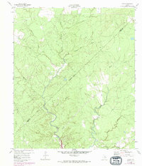
1960 Map of Colita
USGS Topo · Published 1974About this map
Colita and its surrounding woodlands are the focus of this 1960s study, which reveals a rural East Texas landscape defined by an intricate network of waterways. The terrain is marked by the winding courses of Kickapoo Creek and its many tributaries, including Steam Mill Creek and Cedar Creek. A significant transition is visible in the southern portion of the sheet, where the waters of Lake Livingston begin to encroach upon the creek bottoms, reflecting the changing geography of the region as man-made reservoirs reshaped the Trinity River basin.
Find a feature on this map
16 named features on this map. Tap any name to fly to it.
Don’t see what you’re looking for? This feature index may not catch every label — zoom into the map to look around manually.
Map Details
Editions of this 1960 Colita Map
3 editions found
Other maps of this area

1953 · Palestine
USGS Topo · 1:250,000

1954 · Beaumont
USGS Topo · 1:250,000

1955 · New Willard
USGS Topo · 1:62,500

1957 · Beaumont
USGS Topo · 1:250,000

1957 · Palestine
USGS Topo · 1:250,000

1960 · Colita
USGS Topo · 1:24,000

1960 · Carlisle
USGS Topo · 1:24,000

1961 · Onalaska
USGS Topo · 1:24,000

1963 · Groveton West
USGS Topo · 1:24,000

1963 · Groveton East
USGS Topo · 1:24,000