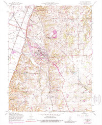
1955 Map of Columbia
USGS Topo · Published 1989About this map
Sugarloaf heights and the American Bottoms define the sharp topographic contrast of this region, where the bluff line separates fertile lowlands from the interior uplands. The city of Columbia serves as a central hub, situated along Illinois 3 at the intersection of several regional rail lines including the Gulf Mobile & Ohio RR and the St Louis Southwestern RR. This mid-century view captures a rural landscape still defined by family-named landmarks and local institutions, such as Sand Bank Sch and Mueller Sch.
Find a feature on this map
58 named features on this map. Tap any name to fly to it.
Don’t see what you’re looking for? This feature index may not catch every label — zoom into the map to look around manually.
Map Details
Editions of this 1955 Columbia Map
3 editions found
Other maps of this area

1888 · St. Louis
USGS Topo · 1:62,500

1910 · Waterloo
USGS Topo · 1:62,500

1912 · Kimmswick
USGS Topo · 1:62,500

1913 · Waterloo
USGS Topo · 1:62,500

1916 · Kimmswick
USGS Topo · 1:62,500

1931 · French Village
USGS Topo · 1:24,000

1933 · Jefferson Barracks
USGS Topo · 1:24,000

1933 · Cahokia
USGS Topo · 1:24,000

1934 · Cahokia
USGS Topo · 1:24,000

1935 · French Village
USGS Topo · 1:24,000