
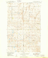
1949 Map of Columbus SW
USGS Topo · Published 1949About this map
Coal Field operations dominate the northern landscape of this 1949 study, which reveals the industrial and social fabric of northwestern North Dakota at the time. The terrain is divided into regional sections named Keller, Border, and Harmonius, reflecting the early rural organization of Burke and Divide counties. In the north, active Strip Mines indicate the region's reliance on mineral extraction, while a network of country schools including School No 1, School No 2, and School No 4 shows the dispersed nature of the agricultural community. Religious and social life are anchored by the Prairie Chapel and its associated Prairie Chapel Cem in the northwest, alongside South St Olaf Ch further south. The map preserves the exact locations of these institutions before the shifting demographics of the later twentieth century altered the rural school and church systems.
Find a feature on this map
12 named features on this map. Tap any name to fly to it.
Don’t see what you’re looking for? This feature index may not catch every label — zoom into the map to look around manually.
Map Details
Editions of this 1949 Columbus SW Map
3 editions found
Other maps of this area

1947 · Noonan
USGS Topo · 1:24,000

1947 · Columbus
USGS Topo · 1:24,000

1949 · Atcoal
USGS Topo · 1:24,000

1949 · Columbus
USGS Topo · 1:24,000

1949 · Noonan SE
USGS Topo · 1:24,000

1949 · Columbus SE
USGS Topo · 1:24,000

1949 · Noonan
USGS Topo · 1:24,000

1950 · Columbus
USGS Topo · 1:62,500

1950 · Noonan
USGS Topo · 1:62,500

1953 · Williston
USGS Topo · 1:250,000