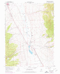
1958 Map of Comins Lake
USGS Topo · Published 1978About this map
Steptoe Valley serves as a central corridor for industry and water management in this high-desert landscape near the city limits of Ely. The Nevada Northern RR cuts across the basin, providing a vital link for the region's mineral interests. Mining history is deeply etched into the eastern slopes of the Humboldt National Forest, where a cluster of historic workings including the Joe Shaft, John Shaft, and Vietti Shaft overlook the valley floor. Water resources are concentrated around Comins Lake and numerous alpine sources like Shallenberger Spring and Fish Pond Springs. The presence of the Monitor Mill (Site) and Argus Mill (Site) suggests an era of processing ore from the nearby canyons. In the valley, the CCC Ranch and Comins Meadow indicate the enduring agricultural use of this well-watered section of the Great Basin.
Find a feature on this map
36 named features on this map. Tap any name to fly to it.
Don’t see what you’re looking for? This feature index may not catch every label — zoom into the map to look around manually.
Map Details
Editions of this 1958 Comins Lake Map
4 editions found
Other maps of this area

1952 · Ely
USGS Topo · 1:125,000

1956 · Ely
USGS Topo · 1:250,000

1958 · Ruth
USGS Topo · 1:24,000

1958 · East Ely
USGS Topo · 1:24,000

1958 · Comins Lake
USGS Topo · 1:24,000

1958 · Ely
USGS Topo · 1:62,500

1958 · McGill
USGS Topo · 1:62,500

1958 · Ely
USGS Topo · 1:24,000

1959 · Ely
USGS Topo · 1:250,000

1959 · Connors Pass
USGS Topo · 1:62,500