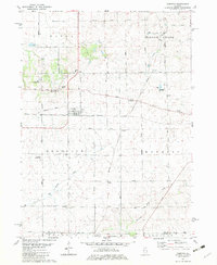
1982 Map of Compton
USGS Topo · Published 1982About this map
Compton stands as a rail junction in the early 1980s, where the tracks of the Burlington Northern intersect with the Chicago and North Western lines. The surrounding landscape of northern Illinois is defined by a dense network of country roads named for local families and early townships, such as Stainbrook Road and Carnahan Road. This agricultural grid is punctuated by small rural settlements like The Burg and Roxbury, the latter situated near the confluence of several townships including Wyoming and Willow Creek.
Find a feature on this map
43 named features on this map. Tap any name to fly to it.
Don’t see what you’re looking for? This feature index may not catch every label — zoom into the map to look around manually.
Map Details
Editions of this 1982 Compton Map
This is the sole edition of this map. No revisions or reprints were ever made.
Other maps of this area

1934 · De Kalb
USGS Topo · 1:62,500

1937 · De Kalb
USGS Topo · 1:62,500

1951 · Earlville
USGS Topo · 1:62,500

1952 · Rochelle
USGS Topo · 1:62,500

1952 · Mendota
USGS Topo · 1:62,500

1958 · Aurora
USGS Topo · 1:250,000

1961 · Aurora
USGS Topo · 1:250,000
1971 · Lee
USGS Topo · 1:24,000
1971 · Paw Paw
USGS Topo · 1:24,000
1971 · Earlville
USGS Topo · 1:24,000