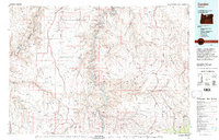
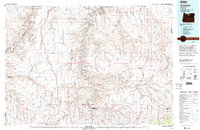
1981 Map of Condon
USGS Topo · Published 1997About this map
The John Day State Scenic Waterway and the Deschutes River National Recreation Area anchor this landscape, where the high desert is carved by complex canyon systems like Cottonwood Canyon and Buck Hollow. The 1980s terrain is characterized by broad plateaus and ridges, including Lamberson Ridge and McInnes Ridge, which support a network of small agricultural hubs and ranching outposts. Settlement patterns follow the topography, with towns such as Condon, Moro, and Fossil serving as primary centers. Transport history is visible through the active Union Pacific line near the northern border and remnants of an Old Railroad Grade further south. Numerous remote landmarks such as Steamboat Rock and the Wilson Airstrip reflect the logistical challenges of this expansive region across Wasco, Sherman, Gilliam, and Wheeler counties.
Find a feature on this map
98 named features on this map. Tap any name to fly to it.
Don’t see what you’re looking for? This feature index may not catch every label — zoom into the map to look around manually.
Map Details
Editions of this 1981 Condon Map
2 editions found
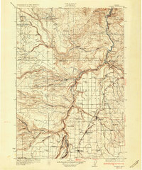
Other maps of this area

1906 · Blalock Island
USGS Topo · 1:125,000

1908 · Blalock Island
USGS Topo · 1:125,000

1916 · Arlington
USGS Topo · 1:125,000

1916 · Condon
USGS Topo · 1:125,000

1926 · Mitchell
USGS Topo · 1:125,000

1928 · Madras
USGS Topo · 1:125,000

1930 · Dufur
USGS Topo · 1:125,000
1931 · Madras
USGS Topo · 1:125,000

1934 · Dufur
USGS Topo · 1:125,000

1934 · The Dalles
USGS Topo · 1:125,000