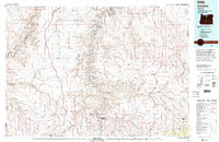
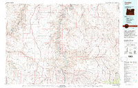
1981 Map of Condon
USGS Topo · Published 1997About this map
The John Day River carves a winding path through the basalt plateaus of North Central Oregon, defining much of the character of this 1981 survey. Designating the John Day State Scenic Waterway, the map illustrates a landscape shaped by both geology and the expansion of the Union Pacific and Oregon-Washington Railroad & Navigation Co. High-desert agriculture and ranching are anchored by the county seats of Condon and Moro, while smaller settlements such as Monkland, Gwendolen, and Mayville sit at the edges of deep canyons like Cottonwood Canyon and Buck Hollow. Notable geological features include the dramatic river bends at the Gooseneck and the prominent Steamboat Rock. The terrain transitions from the open stretches of Grass Valley toward the more complex topography of Shoestring Ridge and the Deschutes River National Recreation Lands in the west.
Find a feature on this map
66 named features on this map. Tap any name to fly to it.
Don’t see what you’re looking for? This feature index may not catch every label — zoom into the map to look around manually.
Map Details
Editions of this 1981 Condon Map
2 editions found
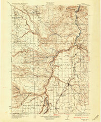
Other maps of this area

1906 · Blalock Island
USGS Topo · 1:125,000

1908 · Blalock Island
USGS Topo · 1:125,000

1916 · Arlington
USGS Topo · 1:125,000

1916 · Condon
USGS Topo · 1:125,000

1926 · Mitchell
USGS Topo · 1:125,000

1928 · Madras
USGS Topo · 1:125,000

1930 · Dufur
USGS Topo · 1:125,000
1931 · Madras
USGS Topo · 1:125,000

1934 · Dufur
USGS Topo · 1:125,000

1934 · The Dalles
USGS Topo · 1:125,000