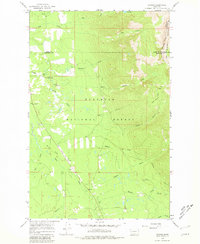
1965 Map of Condon
USGS Topo · Published 1981About this map
The Swan River corridor dominates this mid-1960s survey of the Seeley-Swan Valley, documenting the essential infrastructure of the Flathead National Forest. The small settlement of Condon serves as the focal point, characterized by the Condon PO and the vital operations at the Swan Ranger Sta. The topography transitions from the level Swan Flats into the steep rises of the Swan Range, where the Bob Marshall Wilderness Boundary marks the edge of protected mountain territory. Numerous tributaries, including McKay Creek, Cooney Creek, and Glacier Creek, drain the western slopes toward the main river channel. High-elevation oversight is noted at the Cooney Lookout Tower, a key fixture for forest management in an era when ground-based observation was paramount for fire detection and resource monitoring.
Find a feature on this map
22 named features on this map. Tap any name to fly to it.
Don’t see what you’re looking for? This feature index may not catch every label — zoom into the map to look around manually.
Map Details
Editions of this 1965 Condon Map
3 editions found
Other maps of this area

1921 · Elbow Lake
USGS Topo · 1:125,000

1955 · Choteau
USGS Topo · 1:250,000

1957 · Choteau
USGS Topo · 1:250,000

1958 · Choteau
USGS Topo · 1:250,000

1962 · Choteau
USGS Topo · 1:250,000

1965 · Peck Lake
USGS Topo · 1:24,000

1965 · Condon
USGS Topo · 1:24,000

1965 · Sunburst Lake
USGS Topo · 1:24,000

1965 · Holland Lake
USGS Topo · 1:24,000

1965 · Swan Peak
USGS Topo · 1:24,000