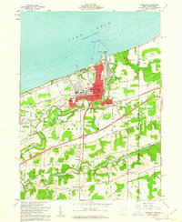
1960 Map of Conneaut
USGS Topo · Published 1962About this map
Lake Erie shoreline industrialization and the maritime-rail transfer economy define this 1960 coastal study. The port at Conneaut Harbor serves as a massive focal point for the region, anchored by the Perry Bluff Ore Storage Area and the Conneaut Harbor Lights. This infrastructure supported a heavy flow of raw materials between the Great Lakes and the steel centers of the interior, facilitated by an extensive rail network including the New York Central and the B & L E railroads.
Find a feature on this map
52 named features on this map. Tap any name to fly to it.
Don’t see what you’re looking for? This feature index may not catch every label — zoom into the map to look around manually.
Map Details
Editions of this 1960 Conneaut Map
3 editions found
Other maps of this area

1900 · Girard
USGS Topo · 1:62,500

1900 · Fairview
USGS Topo · 1:62,500

1906 · Conneaut
USGS Topo · 1:62,500

1950 · Cleveland
USGS Topo · 1:250,000

1950 · Erie
USGS Topo · 1:250,000

1956 · Cleveland
USGS Topo · 1:250,000

1957 · Fairview SW
USGS Topo · 1:24,000

1959 · East Springfield
USGS Topo · 1:24,000

1959 · Beaver Center
USGS Topo · 1:24,000

1959 · Erie
USGS Topo · 1:250,000