
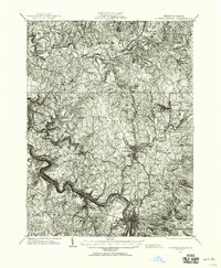
1931 Map of Connellsville
USGS Topo · Published 1954About this map
The Youghiogheny River carves a deep path through this industrial corner of Pennsylvania, defining the transport and settlement patterns of southwestern Westmoreland and Fayette Counties. By the early 1930s, the landscape was densely interconnected by the Baltimore and Ohio RR and the Pennsylvania RR, which served a network of coal-patch towns and manufacturing centers. Connellsville and Scottdale stand as primary hubs, surrounded by numerous company-affiliated settlements like Trotter, Adelaide, and the Star Mines.
Find a feature on this map
127 named features on this map. Tap any name to fly to it.
Don’t see what you’re looking for? This feature index may not catch every label — zoom into the map to look around manually.
Map Details
Editions of this 1931 Connellsville Map
2 editions found
Other maps of this area

1900 · Uniontown
USGS Topo · 1:62,500

1900 · Masontown
USGS Topo · 1:62,500

1900 · Latrobe
USGS Topo · 1:62,500

1902 · Latrobe
USGS Topo · 1:62,500

1902 · Brownsville
USGS Topo · 1:62,500

1902 · Connellsville
USGS Topo · 1:62,500

1903 · Masontown
USGS Topo · 1:62,500

1903 · Latrobe
USGS Topo · 1:62,500

1904 · Mc Keesport
USGS Topo · 1:62,500

1904 · Greensburg
USGS Topo · 1:62,500