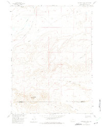
1958 Map of Continental Peak
USGS Topo · Published 1975About this map
Emigrant Trail tracks across the northern expanse of this 1950s high-desert survey, marking the historic corridor used by thousands of westward travelers. The landscape is defined by the high prominence of Continental Peak and the unique formation of the Honeycomb Buttes along the border of Fremont and Sweetwater Counties. This territory served as a vital transit zone where the South Pass Stage Road intersected with rugged drainage systems like Oregon Slough and Meadow Creek. The mapping effort, part of the Missouri River Basin development program, details a network of Jeep Trails providing access to remote water sources such as Sand Creek and Harris Slough. These desert waterways and livestock-era tracks illustrate the sparse but essential infrastructure of mid-century Wyoming rangeland.
Find a feature on this map
12 named features on this map. Tap any name to fly to it.
Don’t see what you’re looking for? This feature index may not catch every label — zoom into the map to look around manually.
Map Details
Editions of this 1958 Continental Peak Map
4 editions found
Other maps of this area

1953 · Radium Springs
USGS Topo · 1:24,000

1953 · Atlantic City
USGS Topo · 1:24,000

1953 · South Pass City
USGS Topo · 1:24,000

1955 · Lander
USGS Topo · 1:250,000

1958 · Lander
USGS Topo · 1:250,000

1958 · Circle Bar Lake
USGS Topo · 1:24,000

1958 · Freighter Gap
USGS Topo · 1:62,500

1958 · The Pinnacles
USGS Topo · 1:62,500

1958 · Dickie Springs
USGS Topo · 1:24,000

1958 · Continental Peak
USGS Topo · 1:24,000