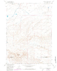
1958 Map of Continental Peak
USGS Topo · Published 1980About this map
The Emigrant Trail traverses this high-desert corridor, marking a historic route of westward expansion across the South Pass region. This landscape, as documented by the Geological Survey during the mid-20th century, illustrates the enduring paths of the Stage Road and various Jeep Trails that connect remote outposts. The topography is defined by the prominent Continental Peak and the distinctive formations of the Honeycomb Buttes along the southern border between Fremont Co and Sweetwater Co.
Find a feature on this map
17 named features on this map. Tap any name to fly to it.
Don’t see what you’re looking for? This feature index may not catch every label — zoom into the map to look around manually.
Map Details
Editions of this 1958 Continental Peak Map
4 editions found
Other maps of this area

1953 · Radium Springs
USGS Topo · 1:24,000

1953 · Atlantic City
USGS Topo · 1:24,000

1953 · South Pass City
USGS Topo · 1:24,000

1955 · Lander
USGS Topo · 1:250,000

1958 · Lander
USGS Topo · 1:250,000

1958 · Circle Bar Lake
USGS Topo · 1:24,000

1958 · Freighter Gap
USGS Topo · 1:62,500

1958 · The Pinnacles
USGS Topo · 1:62,500

1958 · Dickie Springs
USGS Topo · 1:24,000

1958 · Continental Peak
USGS Topo · 1:24,000