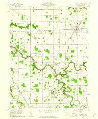
1960 Map of Continental
USGS Topo · Published 1961About this map
The Miami and Erie Canal (Abandoned) cuts through the southwestern corner of this survey, marking a transitioned era of Ohio transportation. By the early 1960s, the landscape was defined by the New York Chicago and St Louis Railroad intersecting at the village of Continental. This rail-driven economy supported small agricultural hubs like Oakwood, Cloverdale, and Dupont, which are scattered along the winding courses of the Auglaize River and Blanchard River. The topography remains relatively level, primarily dedicated to large rectangular farm plots punctuated by local landmarks such as the Claypits near Fairview Cemetery. Genealogists will find a high density of small burial grounds, including Franconia Cemetery and Monroe Cemetery, alongside country places of worship like Prairie Chapel. Near Cloverdale, industry is visible at the Quarry and leisure at Cascade Park along the riverbanks.
Find a feature on this map
33 named features on this map. Tap any name to fly to it.
Don’t see what you’re looking for? This feature index may not catch every label — zoom into the map to look around manually.
Map Details
Editions of this 1960 Continental Map
4 editions found
Other maps of this area

1906 · Columbus Grove
USGS Topo · 1:62,500

1908 · Columbus Grove
USGS Topo · 1:62,500

1908 · Ottawa
USGS Topo · 1:62,500

1909 · Continental
USGS Topo · 1:62,500

1911 · Delphos
USGS Topo · 1:62,500

1944 · Delphos
USGS Topo · 1:62,500

1953 · Fort Wayne
USGS Topo · 1:250,000

1953 · Muncie
USGS Topo · 1:250,000

1956 · Muncie
USGS Topo · 1:250,000

1956 · Fort Wayne
USGS Topo · 1:250,000