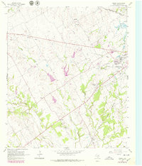
1965 Map of Corbet
USGS Topo · Published 1979About this map
Corsicana anchors the eastern edge of this Navarro County landscape, revealing a mid-century community defined by its social institutions and transit corridors. The map highlights significant specialized facilities like the State Orphans Home and the Odd Fellows and Rebekah Home for Children, illustrating the era's focus on residential care and social fraternal organizations. Rural life outside the city is documented through small settlements such as Drane and Corbet, while an Old Railroad Grade traces a legacy of changing transportation needs alongside the active St Louis Southwestern line.
Find a feature on this map
28 named features on this map. Tap any name to fly to it.
Don’t see what you’re looking for? This feature index may not catch every label — zoom into the map to look around manually.
Map Details
Editions of this 1965 Corbet Map
2 editions found
Other maps of this area

1954 · Dallas
USGS Topo · 1:250,000

1954 · Waco
USGS Topo · 1:250,000

1955 · Waco
USGS Topo · 1:250,000

1956 · Dawson
USGS Topo · 1:24,000

1958 · Dallas
USGS Topo · 1:250,000

1961 · Chatfield
USGS Topo · 1:24,000

1962 · Emhouse
USGS Topo · 1:24,000

1962 · Cryer Creek
USGS Topo · 1:24,000

1963 · Richland
USGS Topo · 1:24,000
1965 · Corsicana
USGS Topo · 1:24,000