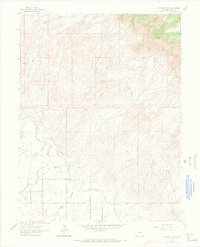
1962 Map of Corcoran Point
USGS Topo · Published 1969About this map
Agricultural development and industrial extraction converge at the northern edge of the Grand Valley in the early 1960s. The landscape is defined by the critical irrigation infrastructure of the Government Highline Canal and Grand Valley Canal, which carve through the arid terrain to support local farming. To the north, the topography rises sharply toward Corcoran Point and Basin Butte, where a cluster of coal operations including the Corcoran Mine, Thomas Mine, and Farmer Mutual Mine indicate the region's mineral heritage. This era shows the expansion of transportation and municipal services, notably with the presence of Walker Field and a nearby substation. Local history is anchored by the Crown Point Cem, while the Ute Principal Meridian serves as a primary surveying benchmark for the surrounding territory.
Find a feature on this map
21 named features on this map. Tap any name to fly to it.
Don’t see what you’re looking for? This feature index may not catch every label — zoom into the map to look around manually.
Map Details
Editions of this 1962 Corcoran Point Map
5 editions found

Other maps of this area

1929 · Roan Creek
USGS Topo · 1:62,500

1934 · Colorado National Monument
USGS Topo · 1:24,000

1956 · Grand Junction
USGS Topo · 1:250,000

1959 · Grand Junction
USGS Topo · 1:250,000

1960 · Grand Junction
USGS Topo · 1:250,000

1962 · Grand Junction
USGS Topo · 1:250,000

1962 · Fruita
USGS Topo · 1:24,000

1962 · Clifton
USGS Topo · 1:24,000

1962 · Colorado National Monument
USGS Topo · 1:24,000

1962 · Grand Junction
USGS Topo · 1:24,000