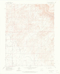
1962 Map of Corcoran Point
USGS Topo · Published 1969About this map
Corcoran Mine and Thomas Mine sit among the elevated terrain of the northern desert landscape, marking a period of active resource extraction in this corner of Mesa County. The irrigation infrastructure in the south reflects the vital water management of the era, dominated by the Government Highline Canal and the Grand Valley Canal. These engineered waterways contrast with the natural drainages of Adobe Creek and Hunter Wash, which cut through the arid flats toward the valley floor. Near the southern boundary, Walker Field and a nearby Substation indicate the developing regional infrastructure. Local history is anchored by the Crown Point Cem and a network of unimproved tracks like the Main Line Road, which connected isolated operations such as the Gibson Mine and Lumber Mutual Mine to the broader valley transport system.
Find a feature on this map
23 named features on this map. Tap any name to fly to it.
Don’t see what you’re looking for? This feature index may not catch every label — zoom into the map to look around manually.
Map Details
Editions of this 1962 Corcoran Point Map
5 editions found

Other maps of this area

1929 · Roan Creek
USGS Topo · 1:62,500

1934 · Colorado National Monument
USGS Topo · 1:24,000

1956 · Grand Junction
USGS Topo · 1:250,000

1959 · Grand Junction
USGS Topo · 1:250,000

1960 · Grand Junction
USGS Topo · 1:250,000

1962 · Grand Junction
USGS Topo · 1:250,000

1962 · Fruita
USGS Topo · 1:24,000

1962 · Clifton
USGS Topo · 1:24,000

1962 · Colorado National Monument
USGS Topo · 1:24,000

1962 · Grand Junction
USGS Topo · 1:24,000