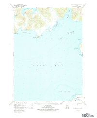
1950 Map of Cordova C-7
USGS Topo · Published 1984About this map
The maritime crossroads of Port Gravina and Orca Bay define this coastal survey, where the deep waters meet the rugged edges of the Chugach National Forest. The map documents a landscape of dramatic peninsulas and sheltered inlets, anchored by the prominent Knowles Head and the eastern reach of Hawkins Island. The coastline is marked by distinct geographical markers such as Snug Corner Cove and Two Moon Bay, which have long served as significant landmarks for navigation in these northern waters.
Find a feature on this map
17 named features on this map. Tap any name to fly to it.
Don’t see what you’re looking for? This feature index may not catch every label — zoom into the map to look around manually.
Map Details
Editions of this 1950 Cordova C-7 Map
4 editions found
Other maps of this area

1948 · Cordova
USGS Topo · 1:250,000

1950 · Cordova C-7
USGS Topo · 1:63,360

1950 · Cordova C-6
USGS Topo · 1:63,360

1950 · Cordova B-7
USGS Topo · 1:63,360

1950 · Cordova D-7
USGS Topo · 1:63,360

1950 · Cordova C-8
USGS Topo · 1:63,360

1951 · Cordova
USGS Topo · 1:250,000

1951 · Cordova D-8
USGS Topo · 1:63,360

1951 · Cordova D-6
USGS Topo · 1:63,360

1951 · Cordova B-8
USGS Topo · 1:63,360