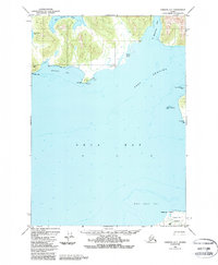
1950 Map of Cordova C-7
USGS Topo · Published 1988About this map
The maritime landscape of the northern Prince William Sound reveals itself through deep inlets and complex coastal features within the Chugach National Forest. The 1950 shoreline is defined by the expansive waters of Port Gravina and Orca Bay, providing a detailed look at the hydrography of the region before modern changes. Navigation aids like the Gravina Pt Light mark the treacherous passage near Gravina Rocks, while the curiously named Hells Hole and Snug Corner Cove suggest the varied experiences of early coastal explorers and mariners. To the south, the northern tip of Hawkins Island appears with Makaka Point overlooking the shifting sands of the Middle Ground Shoal. This survey captures the rugged isolation of the Alaska coast, where land meets sea at prominent landmarks like Knowles Head and Red Head.
Find a feature on this map
19 named features on this map. Tap any name to fly to it.
Don’t see what you’re looking for? This feature index may not catch every label — zoom into the map to look around manually.
Map Details
Editions of this 1950 Cordova C-7 Map
4 editions found
Other maps of this area

1948 · Cordova
USGS Topo · 1:250,000

1950 · Cordova C-7
USGS Topo · 1:63,360

1950 · Cordova C-6
USGS Topo · 1:63,360

1950 · Cordova B-7
USGS Topo · 1:63,360

1950 · Cordova D-7
USGS Topo · 1:63,360

1950 · Cordova C-8
USGS Topo · 1:63,360

1951 · Cordova
USGS Topo · 1:250,000

1951 · Cordova D-8
USGS Topo · 1:63,360

1951 · Cordova D-6
USGS Topo · 1:63,360

1951 · Cordova B-8
USGS Topo · 1:63,360