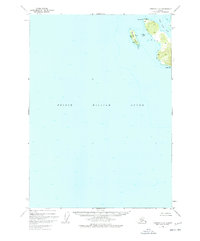
1950 Map of Cordova C-8
USGS Topo · Published 1978About this map
Goose Island and the neighboring coastline of Prince William Sound define this 1950 coastal survey. The map emphasizes the maritime character of the region, specifically around the waters of Snug Corner Cove. While much of the terrain is characterized by the prominent rises at Knowles Head and Porcupine Pt, human presence is noted by a cluster of Cabins on the western shore of Goose Island. This map provides a detailed record of shoreline geometry and hydrographic depths recorded during the mid-twentieth century, capturing the area before significant changes in navigational mapping standards. The inclusion of Gull Island and other small outcrops highlights the specific maritime hazards and sheltered waters that defined the local geography for those living in or traveling through this part of Alaska.
Find a feature on this map
7 named features on this map. Tap any name to fly to it.
Don’t see what you’re looking for? This feature index may not catch every label — zoom into the map to look around manually.
Map Details
Editions of this 1950 Cordova C-8 Map
3 editions found
Other maps of this area

1948 · Cordova
USGS Topo · 1:250,000

1950 · Cordova C-7
USGS Topo · 1:63,360

1950 · Cordova B-7
USGS Topo · 1:63,360

1950 · Cordova D-7
USGS Topo · 1:63,360

1950 · Cordova C-8
USGS Topo · 1:63,360

1951 · Seward
USGS Topo · 1:250,000

1951 · Cordova
USGS Topo · 1:250,000

1951 · Seward B-1
USGS Topo · 1:63,360

1951 · Seward D-1
USGS Topo · 1:63,360

1951 · Cordova D-8
USGS Topo · 1:63,360