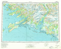
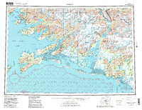
1959 Map of Cordova
USGS Topo · Published 1970About this map
Cordova sits as the central hub of this coastal survey, where the rugged peaks of the Chugach Mountains meet the waters of Orca Inlet and Orca Bay. The map documents a critical transition in Alaskan transportation history, showing the path of the Copper River and Northwestern Railway alongside the developing Copper River Highway. To the east, the sprawling Copper River Delta is intricately detailed with its shifting waterways, including Alaganik Slough and Kokinhenik Slough, which dominate the landscape between the gulf and the mountains.
Find a feature on this map
153 named features on this map. Tap any name to fly to it.
Don’t see what you’re looking for? This feature index may not catch every label — zoom into the map to look around manually.
Map Details
Editions of this 1959 Cordova Map
6 editions found

Other maps of this area

1946 · Blying Sound
USGS Topo · 1:250,000

1948 · Cordova
USGS Topo · 1:250,000

1948 · Middleton Island
USGS Topo · 1:250,000

1950 · Middleton Island
USGS Topo · 1:250,000

1950 · McCarthy A-8
USGS Topo · 1:63,360

1950 · Bering Glacier
USGS Topo · 1:250,000

1950 · Icy Bay
USGS Topo · 1:250,000

1950 · Valdez A-3
USGS Topo · 1:63,360

1950 · Cordova B-2
USGS Topo · 1:63,360

1950 · Cordova C-7
USGS Topo · 1:63,360