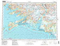
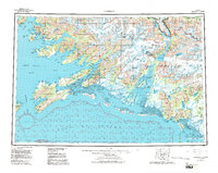
1959 Map of Cordova
USGS Topo · Published 1986About this map
Cordova serves as the focal point of this coastal survey, situated where Orca Inlet meets the vast glacial drainage of the Copper River. The map illustrates the region's mid-century infrastructure, centered on the Copper River Highway and the Cordova Airport, while recording remote settlements like Ellamar and Tatitlek along the inlets of Prince William Sound. The landscape is dominated by the ice-carved peaks of the Chugach Mountains, featuring landmarks such as Cordova Peak and the McKinley Peak Mine. To the east, the Bering River flows toward Controller Bay, marking a transition toward the reaches of Wrangell-Saint Elias National Park. The alignment of glaciers like the Miles Lake calving front against the jagged coastline provides a detailed record of the maritime and terrestrial boundary during this period of geological and aerial revision.
Find a feature on this map
34 named features on this map. Tap any name to fly to it.
Don’t see what you’re looking for? This feature index may not catch every label — zoom into the map to look around manually.
Map Details
Editions of this 1959 Cordova Map
6 editions found

Other maps of this area

1946 · Blying Sound
USGS Topo · 1:250,000

1948 · Cordova
USGS Topo · 1:250,000

1948 · Middleton Island
USGS Topo · 1:250,000

1950 · Middleton Island
USGS Topo · 1:250,000

1950 · McCarthy A-8
USGS Topo · 1:63,360

1950 · Bering Glacier
USGS Topo · 1:250,000

1950 · Icy Bay
USGS Topo · 1:250,000

1950 · Valdez A-3
USGS Topo · 1:63,360

1950 · Cordova B-2
USGS Topo · 1:63,360

1950 · Cordova C-7
USGS Topo · 1:63,360