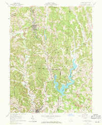
1961 Map of Corning
USGS Topo · Published 1971About this map
Corning and Glouster anchor this topographic study of the coal-rich hills and valleys at the intersection of Perry, Athens, and Morgan counties. The landscape is defined by the extensive waters of Burr Oak Reservoir, created by the Tom Jenkins Dam, which dominates the southeastern quadrant. This 1961 field check captures the region as it balanced industrial extraction with new conservation efforts, evidenced by the proximity of a Strip Mine to the protected boundaries of Wayne National Forest and the Trimble State Wildlife Area.
Find a feature on this map
73 named features on this map. Tap any name to fly to it.
Don’t see what you’re looking for? This feature index may not catch every label — zoom into the map to look around manually.
Map Details
Editions of this 1961 Corning Map
5 editions found

Other maps of this area

1903 · Athens
USGS Topo · 1:62,500

1904 · Chesterhill
USGS Topo · 1:62,500

1905 · Athens
USGS Topo · 1:62,500

1906 · Chesterhill
USGS Topo · 1:62,500

1910 · Mc Connelsville
USGS Topo · 1:62,500

1911 · New Lexington
USGS Topo · 1:62,500

1947 · Columbus
USGS Topo · 1:250,000

1949 · Clarksburg
USGS Topo · 1:250,000

1956 · Clarksburg
USGS Topo · 1:250,000

1960 · Amesville
USGS Topo · 1:24,000