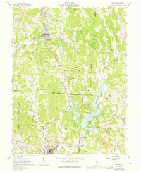
1961 Map of Corning
USGS Topo · Published 1976About this map
Corning and Glouster anchor this 1961 survey of the coal and timber country where Perry, Athens, and Morgan Counties meet. The landscape is defined by the extensive Wayne National Forest and the waters of Burr Oak Reservoir, which was formed following the completion of the Tom Jenkins Dam. This era shows a transition in local industry, with several Strip Mines and gas wells scattered across the hillsides, particularly near Drakes and Hollister. The Penn Central railroad remains a vital corridor for the region, threading through Rendville and following the course of Sunday Creek. Genealogists will find numerous family landmarks and resting places, including Mt Carmel Cem, Stuart Cem, and Asberry Cem. The presence of small communities like McLeish, Palos, and Bishopville provides a detailed record of mid-century settlement patterns in southeastern Ohio prior to later twentieth-century shifts.
Find a feature on this map
71 named features on this map. Tap any name to fly to it.
Don’t see what you’re looking for? This feature index may not catch every label — zoom into the map to look around manually.
Map Details
Editions of this 1961 Corning Map
5 editions found

Other maps of this area

1903 · Athens
USGS Topo · 1:62,500

1904 · Chesterhill
USGS Topo · 1:62,500

1905 · Athens
USGS Topo · 1:62,500

1906 · Chesterhill
USGS Topo · 1:62,500

1910 · Mc Connelsville
USGS Topo · 1:62,500

1911 · New Lexington
USGS Topo · 1:62,500

1947 · Columbus
USGS Topo · 1:250,000

1949 · Clarksburg
USGS Topo · 1:250,000

1956 · Clarksburg
USGS Topo · 1:250,000

1960 · Amesville
USGS Topo · 1:24,000