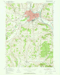
1955 Map of Cortland
USGS Topo · Published 1973About this map
The Tioughnioga River and its West Branch serve as the central corridor for the city of Cortland and the neighboring village of Homer, defining a landscape where valley-floor industry meets rising terrain. This mid-century view captures a dense network of rail infrastructure, including the Lehigh Valley, D L & W RR, and Lackawanna RR, which historically facilitated the region's manufacturing and dairy transport. Educational and civic life is anchored by the State College campus and the Fairgrounds, while the surrounding hills like Cosmos Hill and Tuller Hill transition into large-scale conservation efforts within the State Reforestation Area. Genealogists will find detailed locations for cemeteries including St Marys Cem and the Virgil Rural Cem, alongside rural landmarks like Elm Stump Ch and several numbered schoolhouses that once served small communities like Pokeville and Gracie.
Find a feature on this map
57 named features on this map. Tap any name to fly to it.
Don’t see what you’re looking for? This feature index may not catch every label — zoom into the map to look around manually.
Map Details
Editions of this 1955 Cortland Map
4 editions found
Other maps of this area

1898 · Moravia
USGS Topo · 1:62,500

1900 · Dryden
USGS Topo · 1:62,500

1902 · Moravia
USGS Topo · 1:62,500

1903 · Cortland
USGS Topo · 1:62,500

1903 · Harford
USGS Topo · 1:62,500

1906 · Catatonk
USGS Topo · 1:125,000

1942 · Groton
USGS Topo · 1:24,000

1943 · Groton
USGS Topo · 1:31,680
1943 · Sempronius
USGS Topo · 1:31,680
1944 · Homer
USGS Topo · 1:31,680